Quantum GIS 64 bit Download for PC Windows 11
Quantum GIS Download for Windows PC
Quantum GIS free download for Windows 11 64 bit and 32 bit. Install Quantum GIS latest official version 2025 for PC and laptop from FileHonor.
Free cross-platform desktop geographic information system application that supports viewing, editing, and analysis of geospatial data.

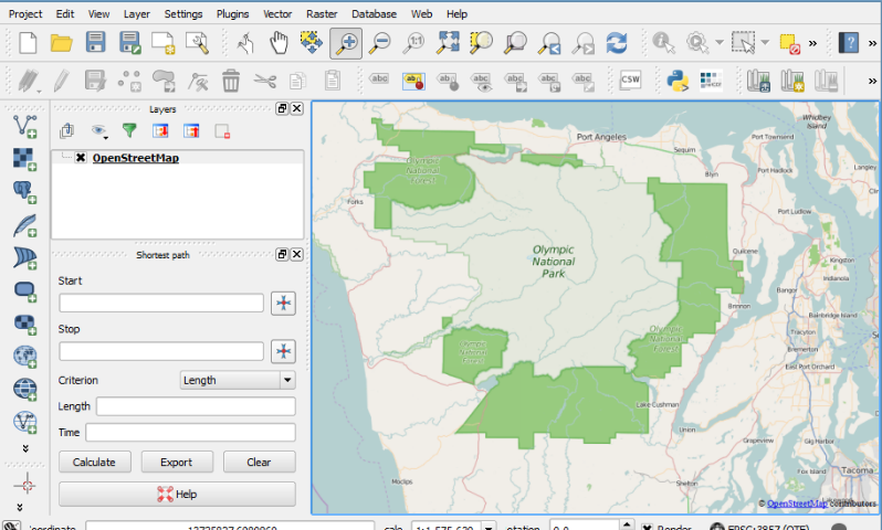
QGIS is a free and open-source cross-platform desktop geographic information system application that supports viewing, editing, and analysis of geospatial data. Create, edit, visualise, analyse and publish geospatial information on Windows, Mac, Linux, BSD (Android coming soon).
Key Features
View data
You can view and overlay vector and raster data in different formats and projections without conversion to an internal or common format.
Explore data and compose maps
You can compose maps and interactively explore spatial data with a friendly GUI.
Create, edit, manage and export data
You can create, edit, manage and export vector and raster layers in several formats.
Analyze data
You can perform spatial data analysis on spatial databases and other OGR- supported formats. QGIS currently offers vector analysis, sampling, geoprocessing, geometry and database management tools.
Publish maps on the Internet
QGIS can be used as a WMS, WMTS, WMS-C or WFS and WFS-T client, and as a WMS, WCS or WFS server. (See section Working with OGC Data.) Additionally, you can publish your data on the Internet using a webserver with UMN MapServer or GeoServer installed.
Extend QGIS functionality through plugins
QGIS can be adapted to your special needs with the extensible plugin architecture and libraries that can be used to create plugins. You can even create new applications with C++ or Python!
"FREE" Download Complete Internet Repair for PC
Full Technical Details
- Category
- Internet Tools
- This is
- Latest
- License
- Freeware
- Runs On
- Windows 10, Windows 11 (64 Bit, 32 Bit, ARM64)
- Size
- 498 Mb
- Updated & Verified
Download and Install Guide
How to download and install Quantum GIS on Windows 11?
-
This step-by-step guide will assist you in downloading and installing Quantum GIS on windows 11.
- First of all, download the latest version of Quantum GIS from filehonor.com. You can find all available download options for your PC and laptop in this download page.
- Then, choose your suitable installer (64 bit, 32 bit, portable, offline, .. itc) and save it to your device.
- After that, start the installation process by a double click on the downloaded setup installer.
- Now, a screen will appear asking you to confirm the installation. Click, yes.
- Finally, follow the instructions given by the installer until you see a confirmation of a successful installation. Usually, a Finish Button and "installation completed successfully" message.
- (Optional) Verify the Download (for Advanced Users): This step is optional but recommended for advanced users. Some browsers offer the option to verify the downloaded file's integrity. This ensures you haven't downloaded a corrupted file. Check your browser's settings for download verification if interested.
Congratulations! You've successfully downloaded Quantum GIS. Once the download is complete, you can proceed with installing it on your computer.
How to make Quantum GIS the default Internet Tools app for Windows 11?
- Open Windows 11 Start Menu.
- Then, open settings.
- Navigate to the Apps section.
- After that, navigate to the Default Apps section.
- Click on the category you want to set Quantum GIS as the default app for - Internet Tools - and choose Quantum GIS from the list.
Why To Download Quantum GIS from FileHonor?
- Totally Free: you don't have to pay anything to download from FileHonor.com.
- Clean: No viruses, No Malware, and No any harmful codes.
- Quantum GIS Latest Version: All apps and games are updated to their most recent versions.
- Direct Downloads: FileHonor does its best to provide direct and fast downloads from the official software developers.
- No Third Party Installers: Only direct download to the setup files, no ad-based installers.
- Windows 11 Compatible.
- Quantum GIS Most Setup Variants: online, offline, portable, 64 bit and 32 bit setups (whenever available*).
Uninstall Guide
How to uninstall (remove) Quantum GIS from Windows 11?
-
Follow these instructions for a proper removal:
- Open Windows 11 Start Menu.
- Then, open settings.
- Navigate to the Apps section.
- Search for Quantum GIS in the apps list, click on it, and then, click on the uninstall button.
- Finally, confirm and you are done.
Disclaimer
Quantum GIS is developed and published by QGIS, filehonor.com is not directly affiliated with QGIS.
filehonor is against piracy and does not provide any cracks, keygens, serials or patches for any software listed here.
We are DMCA-compliant and you can request removal of your software from being listed on our website through our contact page.


